Followers

Wednesday, November 22, 2017

Emerging Phone Service May Cost You


Phone companies will be more aggressive in blocking robocalls to customers' phones, but it may come with a cost.

The Federal Communications Commission yesterday issued an order to "expressly authorize voice service providers to block robocalls that appear to be from telephone numbers that do not or cannot make outgoing calls, without running afoul of the FCC's call completion rules."

The new authorization from the FCC applies to voice service providers including mobile phone carriers, traditional landline phone companies like AT&T and Verizon, and VoIP carriers such as cable companies.

Carriers will be "allowed to block calls purporting to be from invalid numbers, like those with area codes that don't exist, from numbers that have not been assigned to a provider, and from numbers allocated to a provider but not currently in use," the FCC said.

Read more here.


Tuesday, November 21, 2017

Evidence of a Wet Sahara


There is no doubt that climate changes take place. The Sahara of Africa is an example. Between 10,000 and 4000 years ago the Sahara was much wetter. There were many lakes and rivers and it was possible to travel great distances along the interconnected water systems.

The map below shows the water ways of the eastern African Shear Zone. The waters of the Sahara collected and flowed along rifts. These include the Atbara Rift, the Blue Nile Rift, the White Nile Rift, the Abu Gabra Rift, the Bahr El-Arab Rift, and the Muglad Rift. There were also basins that filled with water, especially during the rainy monsoon season, and Lake Victoria. Hydrologic studies indicate many periods of flooding from the Nile to the Atlantic coast of Nigeria.


The Central African Shear Zone (shown below) was riddled with lakes and rivers. The gray shaded areas show the ancient water ways in the African Sheer Zone. The area was prone to flooding.


In 1984, United States Geological Survey researchers located some of the covered channels with the aid of a satellite navigation device modified for land use. Archaeologist William P. McHugh directed excavations on the shorelines of two sand-covered valleys. McHugh uncovered hand axes and other stone artifacts, evidence of tool workshops used intermittently over tens of thousands of years at the ancient water systems. Animals uncovered at the sites included crocodiles and turtles. Researchers estimate that the annual rainfall during the Aqualithic was at least 20 inches.

Noah lived in the region of Lake Chad. This lake is located at the northeastern boundary of Nigeria, between Nigeria and Chad. The region is called Borno, which means "Land of Noah." This is the only place on earth that is claimed by the native population to be Noah's homeland.


There is a considerable evidence that boats were once prevalent in the Sahara. The black mahogany Dufuna dugout (above) was found in the Sudan buried 16 feet under clays and sands whose alternating sequence showed evidence of deposition in standing and flowing water. The dugout is 8000 years old. By comparison, Egypt's oldest boat is only about 5000 years old. 

Peter Breunig (University of Frankfurt, Germany) has written this description of the Dufuna boat: “The bow and stern are both carefully worked to points, giving the boat a notably more elegant form”, compared to “the dugout made of conifer wood from Pesse in the Netherlands, whose blunt ends and thick sides seem crude”. Judging by stylistic sophistication, Breunig reasons that, “It is highly probable that the Dufuna boat does not represent the beginning of a tradition, but had already undergone a long development, and that the origins of water transport in Africa lie even further back in time.”

Boats appear on prehistoric rock paintings in the Sahara. Many show people transporting long horn cows by boat. The Proto-Saharan were cattle-herding. Here are examples of the sickle, incurved sickle, square, incurved square, and flared boat types found on the prehistoric rock art of the Central Eastern Desert of Egypt.


The historicity of Noah’s concern for animals is supported by the discovery that Proto-Saharan rulers kept royal menageries of exotic animals. The oldest known zoological collection was found during the 2009 excavations at the city of Nekhen on the Nile. The royal menagerie dates to about 3500 BC and included hippos, elephants, baboons and wildcats. Noah would have known Nekhen. This painting was found on the wall of a tomb in Nekhen, the earliest known Horite Hebrew shrine city.


Related reading: The Historicity of Noah's Flood; Boats and Cows of the Nilo-Saharans

Wednesday, November 15, 2017

Forests in the Transantarctic Mountains


Researchers have identified two distinct environments at the South Pole at the close of the Permian Period. There was a warm rainforest with tree-ferns, palm trees and baobab trees at the lower elevations, and a cooler mountainous region dominated by beech trees and conifers.


Fossil tree trunk in what was an ancient polar forest
Credit: Erik Gulbranson


During Antarctica's summer, from late November through January, UW-Milwaukee geologists Erik Gulbranson and John Isbell climbed the McIntyre Promontory's frozen slopes in the Transantarctic Mountains. High above the ice fields, they combed the mountain's gray rocks for fossils from the continent's green, forested past.

By the trip's end, the geologists had found fossil fragments of 13 trees. The discovered fossils reveal that the trees are over 260 million years old, meaning that this forest grew at the end of the Permian Period, before the first dinosaurs, when Antarctica was still at the South Pole.

At the Permian Period's end, Antarctica was warmer and more humid than it is today. 

By studying the preserved tree rings, Gulbranson and colleagues have found that these trees transitioned from summer activity to winter dormancy rapidly, perhaps within a month

Read more here


Thursday, November 9, 2017

Build a 3-D Zoetrope


Build Your Own 3D Zoetrope With This Desktop Animation Kit

Inspired by the pre-film animation devices of the 1800’s, company 4-Mation has created a DIY kit that allows users to produce their very own tabletop animations. Unlike historic zoetropes, the kit is built for 3D objects. Using synchronized strobes and carousel rotation, the machine animates objects placed on its circular base, giving life to ravenous fish or leaping frogs.

The kit is available in three models. You can choose from a laser cut plywood frame, a machined walnut frame (as seen in the included videos), and an electronics version which comes with instructions for how to cut your own.

Read more here.


Tuesday, November 7, 2017

Ice Houses in the Persian Desert


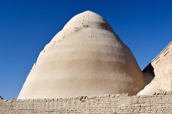
Ancient Persia (Iran) was famous for mud structures to collect fertilizer (pigeon towers) and to create ice in the desert. The ice houses are called yakhchāls.

Beginning around 400 BC, Persian engineers created domed yakhchāls for the production of ice. These can still be seen in Iran in the region of Isfahan. The structures have an underground square-shaped containment area over which the dome was built. The dome and exterior surface of the yakhchal was waterproofed with a layer of mortar called sarooj. It is a mixture of clay, sand, ash, goat hair, and lime.

Ice was brought from the mountains and placed inside the containment area to start the process of freezing. Often walls were built to keep the water shaded as it was channeled to the yakhchāls so it would freeze faster. Water captured in the yakhchal would freeze overnight during the colder months. The ice was then cut into blocks so that it could be transported. In addition to storing drinking water, the yakhchal was also used to keep food from spoiling much as we use refrigerators.

The ice is used to make faloodeh, a traditional Persian frozen dessert made with thin noodles and semi-frozen syrup.

Read more here and here.

Watch this video of the inside of a yakhchal.


Related reading: The Yakhchals of Persia

Thursday, November 2, 2017

Massive Polynya in Antarctica


An hole in the sea ice as large as lake superior has opened in Antarctica. This is called a "polynya" and scientists have observed them before. This hole is unusual because of it great size. It has a diameter of about 30,000 square miles.

The first time scientists spotted something like this was in the 1970’s, but the opening disappeared for several decades before appearing again.

The blue curves represent the ice edge, and the polynya is the dark open water within the ice pack. Image: MODIS-Aqua via NASA Worldview; sea ice contours from AMSR2 ASI via University of Bremen

A polynya forms when water that is above freezing moves from the lower depths of the ocean to the surface. Heat transfers from the warmer water to the ice, melting it, and preventing new ice from forming. This type of polynya is called a "sensible heat" polynya. The ocean itself provides the heat needed to melt the ice. Sensible-heat polynyas usually form in mid-ocean areas, far from coasts or other barriers.

Polynyas are important as a source of heat and moisture in the atmosphere. This has an effect on the climate of the region. Polynyas also provide access between the ocean and atmosphere for a variety of animals, including seals and penguins. The overturning ocean water in a polynya brings nutrients to the surface, like phytoplankton, microscopic plant-like organisms that are a food source for marine life. During the summer, Antarctic polynyas are one of the most biologically productive regions in the world's oceans.