Followers

Showing posts with label Earth Science. Show all posts

Monday, January 30, 2023

Dr. Judith Curry Deserves a Fair Hearing


Dr. Judith Curry is a true climatologist. She once headed the department of earth and atmospheric sciences at the Georgia Institute of Technology, until she gave up on the academy so that she could express herself independently. She once told a journalist, “Independence of mind and climatology have become incompatible.”

She added, "Climatology has become a political party with totalitarian tendencies,” she charges. “If you don’t support the UN consensus on human-caused global warming, if you express the slightest skepticism, you are a ‘climate-change denier,’ a stooge of Donald Trump, a quasi-fascist who must be banned from the scientific community.”

The climate models used by scientists working for the United Nations cannot explain why the climate suddenly cooled between 1950 and 1970, giving rise to widespread warnings about the onset of a new ice age.

Curry notes that between 1910 and 1940, the planet warmed during a climatic episode that resembles our own, down to the degree. The warming cannot be blamed on CO2 emissions because the carbon-dioxide emissions from burning fossil fuels were relatively small in those years. Curry says, “almost half of the warming observed in the twentieth century came about in the first half of the century, before carbon-dioxide emissions became large.”

Speaking of climate changes, she points to natural factors, of which there are many. These factors reveal far greater complexity than is generally acknowledged by global warming alarmists.


The following organizations are in agreement that climate changes: the U.S. National Academy of Sciences, the National Academies of more than 30 other countries, the American Association for the advancement of science (AAAS), the American Meteorological Society (AMS), The American Institute of Physics (AIP), The Geological Society of America (GSA), The American Physical Society (APS), and the American Geophysical Union (AGU).

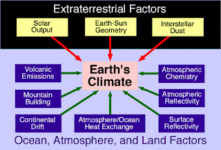
However, among the scientists in these organizations there is a range of positions as to which factors contribute most to warming. All tend to agree that solar radiance and Earth-Sun geometry are very significant. Yet we hear about this less than we hear about the danger of CO2 emissions from fossil fuel energy sources.

Earth's climate varies from region to region and from age to age. Therefore, it is misleading to speak of "climate change". Instead, we should speak of "climate changes" over vast periods of time. The Pleistocene glacial epoch (2,600,000-11,700 years ago) saw substantial variations in the extent of glaciers and ice sheets. These variations were driven by changes in the distribution of solar radiation across Earth’s surface. The insolation pattern is strongly affected by the geometry of Earth’s orbit around the Sun and by the orientation, or tilt, of Earth’s axis relative to the direct rays of the Sun.

Worldwide, the most recent glacial period, or ice age, culminated about 21,000 years ago in what is called the Last Glacial Maximum (LGM). During this time, continental ice sheets extended well into the middle latitude regions of Europe and North America, reaching as far south as present-day London and New York City. Global annual mean temperature appears to have been about 4–5 °C (7–9 °F) colder than in the mid-20th century.

The Sahara was once wet, and with on-going reforestation projects and changes in monsoons, it will likely be wet again.

The Botswanan basin in southern Africa was once a sea, filled by water from the Angolan Highlands. Thousands of stoneage tools have been found there. 

At its peak, Mega Lake Chad covered more than 400,000 square kilometers (150,000 square miles), making it the largest lake on Earth today.

Researchers identified two distinct environments at the South Pole at the close of the Permian Period. There was a warm rainforest with tree-ferns, palm trees, and baobab trees at the lower elevations, and a cooler mountainous region dominated by beech trees and conifers.

NASA bases climate change on a 136-year record. According to NASA, 16 of the 17 warmest years in the 136-year record all have occurred since 2001, with the exception of 1998. What happened to make 1998 different? This marked the completion of Earth's axial precession, a cycle of about 25,800 years (Earth's Great Year). Obviously, we have no climate records going back that far.

In the cycle of Earth’s Great Year, the line off the North Pole axis (extending toward Polaris) scribes a complete circle in the heavens about every 25,800 years. A complete cycle takes between 25,000 and 28,000 years, depending on the amount of Earth's wobble. One cycle is Earth’s Great Year. Climate and atmospheric changes appear to become more acute toward the end and beginning of a new year.

Judith Curry is not alone in her consideration of natural causes. In June 2013, Dr. Roy W. Spencer wrote, "Hundreds of millions of dollars that have gone into the expensive climate modelling enterprise has all but destroyed governmental funding of research into natural sources of climate change. For years the modelers have maintained that there is no such thing as natural climate change…yet they now, ironically, have to invoke natural climate forces to explain why surface warming has essentially stopped in the last 15 years!"


Friday, August 26, 2022

The Chibanian Age of Geologic Time


Schematic illustration of Earth's magnetic field.
Credits: Peter Reid, The University of Edinburgh


A geomagnetic reversal is a change in a planet's magnetic field such that the positions of magnetic north and magnetic south are interchanged.

About 770,000 years ago, Earth’s magnetic fields reversed, swapping magnetic north and south for the last known time. That ushered in a new geological age which scientists have now named the Chibanian.

The Chibanian age is named after the Japanese prefecture Chiba where a cliff wall was found with an exposed layer of marine deposits and mineral debris about 770,000 years old.

When geologists studied the minerals inside, they found evidence of the last known shifting of Earth’s magnetic fields. The planet’s outer core generates its magnetic field, a kind of shield that protects Earth from solar wind.

As molten rock cools, iron-bearing minerals form. They align themselves with the magnetic field, then solidify, acting as a kind of snapshot of Earth’s magnetic field at the time cooling occurred.

The minerals in Chiba allowed geologists to date the last known switch of magnetic fields to about 774,000 years ago. They named the reversal event the Brunhes-Matuyama reversal in honor of the French geophysicist Bernard Brunhes (1867-1910) and the Japanese geophysicist Motonori Matuyama (1884-1958).

Matuyama was the first to provide systematic evidence that the Earth's magnetic field had been reversed in the early Pleistocene and to suggest that long periods existed in the past in which the polarity was reversed.

Antoine Joseph Bernard Brunhes was a pioneer in paleomagnetism. His 1906 discovery of geomagnetic reversal has since been verified. The current period of normal polarity, called Brunhes Chron, is named for him.

Friday, August 20, 2021

Sea Floor Expansion Pushes Continents Apart


Ridge zone where sea floor spreads.


Only a small portion of the oceanic crust produced in the Atlantic is subducted. Most is rising and the rising rock appears to be slowly pushing the continents of North and South America further apart from Europe and Africa. The spreading distance between North America and Europe is caused by mantle convection. The Atlantic is expanding by a couple of inches a year. 

The North American and Eurasian Plates are moving away from each other along the line of the Mid- Atlantic Ridge. The Ridge extends into the South Atlantic Ocean between the South American and African Plates. The ocean ridge rises to between 1.24 and 1.86 miles above the ocean floor, and a rift valley at its crest marks the location where the two plates are moving apart.

The Mid Atlantic Ridge has developed as a consequence of the divergent motion between the Eurasian and North American, and African and South American Plates. As the mantle rises towards the surface below the ridge the pressure is lowered (decompression) and the hot rock starts to partially melt. This produces basaltic volcanoes when an eruption occurs above the surface. An example is Eyjafjallajökull in Iceland

As the plates move further apart new ocean lithosphere is formed at the ridge and the ocean basin gets wider. This process is known as “sea floor spreading” and results in a symmetrical alignment of the rocks of the ocean floor which get older with distance from the ridge crest.


Sunday, June 14, 2020

Mapping the Earth's Interior


Using a new technique originally designed to explore the cosmos, scientists have unveiled structures deep inside the Earth, paving the way for a new map revealing what Earth's interior looks like.

Brice Ménard, an astrophysicist at Johns Hopkins University, reports, "We were finally able to identify the seismic echoes and use them to create a map."

Doyeon Kim, a seismologist at the University of Maryland and co-author on the paper, explains: "Imagine you're outside in the dark. If you clap your hands and then hear an echo, you know that a wall or vertical structure is in front of you. This is how bats echolocate their surroundings."

Using this principle, the team used the Sequencer algorithm to parse through thousands of seismograms for echoes to create a new map showing details of the Earth's mantle, just above the liquid iron core.

Read more here.


Friday, December 14, 2018

Zealandia: The Eighth Continent


A study done by earth scientists in New Zealand and Australia claims that a continent is hidden under the ocean. In their paper, titled 'Zealandia: Earth's Hidden Continent,' the geologists argue that Zealandia has all four attributes necessary to be considered a continent.

It is believed that the 94 per cent of Zealandia that is submerged broke off from Australia and sank 60-85 million years ago.

At 4.9 million square kilometers, Zealandia would be the smallest continent. Zealandia's crust is much shallower than the surrounding oceanic crust, and more closely resembles continental crust rather than oceanic crust. Further, a narrow strip of oceanic crust separates Australia from Zealandia.

The proposed world map below shows Zealandia, the eighth continent. Though most of the continent is submerged, scientists say it has all the geologic hallmarks of a separate continent.


A six-year study by the GNS Science research institute in New Zealand found that there could be tens of billions of dollars worth of fossil fuels in offshore regions around the landmass.

Read more here and here.


Thursday, November 2, 2017

Massive Polynya in Antarctica


An hole in the sea ice as large as lake superior has opened in Antarctica. This is called a "polynya" and scientists have observed them before. This hole is unusual because of it great size. It has a diameter of about 30,000 square miles.

The first time scientists spotted something like this was in the 1970’s, but the opening disappeared for several decades before appearing again.

The blue curves represent the ice edge, and the polynya is the dark open water within the ice pack. Image: MODIS-Aqua via NASA Worldview; sea ice contours from AMSR2 ASI via University of Bremen

A polynya forms when water that is above freezing moves from the lower depths of the ocean to the surface. Heat transfers from the warmer water to the ice, melting it, and preventing new ice from forming. This type of polynya is called a "sensible heat" polynya. The ocean itself provides the heat needed to melt the ice. Sensible-heat polynyas usually form in mid-ocean areas, far from coasts or other barriers.

Polynyas are important as a source of heat and moisture in the atmosphere. This has an effect on the climate of the region. Polynyas also provide access between the ocean and atmosphere for a variety of animals, including seals and penguins. The overturning ocean water in a polynya brings nutrients to the surface, like phytoplankton, microscopic plant-like organisms that are a food source for marine life. During the summer, Antarctic polynyas are one of the most biologically productive regions in the world's oceans.

Friday, October 20, 2017

Geologic Studies Confirm Biblical Data


Mysterious keyhole structures at Al Wadi, in the Saudi Arabian desert, observed by archaeologist David Kennedy from a helicopter.


Three regions are named in the Bible as being rich in minerals like copper and gold: Havilah at the source of the Nile in Kush (Genesis 2:11); Dedan in southwestern Arabia, and Ophir, south of Dedan.

The region of Dedan and Ophir is riddled with lava caves dating to many thousands of years ago. The archaic populations of Dedan and Ophir lived in these caves and collected epithermal gold. This is gold that is mined close to the surface because it has been brought up by volcanism.

Scientists have been studying this area. They are especially interested in the lava caves of Harrat Khaybar. Here researchers have found hundreds of stone walls surrounding large basaltic lava fields. The largest of the walls reaches almost 1,700 feet long. The stone walls were built during active volcanism. The structures at Harrat Khaybar are regarded as “works of the old men” by the Bedouin. The Bible calls them the "mighty men of old."


The lava caves and walls of Harrat Khaybar (Arabic for "White Mountain") are in the news today. Scientists have known about this region for 30 years. This is the region of biblical Dedan and Ophir, described as rich in precious metals. This is probably the oldest known site of recovery of copper and gold, and the miners lived in the caves, many of which collapsed long ago. Ophir was one the sons of Joktan (Gen. 10:26-28). The Joktanite clans still live in this region of Arabia.

This area of Saudi Arabia and Yemen is a site for porphyry copper and epithermal gold deposits captured by people living in the caves.


In 1946 an inscribed pottery shard was found at Tell Qasile (Tel Aviv) dating to the eight century BC. The Paleo-Hebrew inscription says, "gold of Ophir for Beth-Horon [...] 30 shekels." This, and other such finds, confirm that gold was exported from Ophir. 

Every three years Solomon received tribute of gold, silver, sandalwood, precious stones, ivory, apes and peacocks from Ophir. Solomon's navy traveled to Ophir, taking "four hundred and twenty talents of gold from there" (1 Kin. 9:26-28; 22:48; 2 Chr. 8:17-18; 9:10).


Wednesday, September 27, 2017

Zealandia


The proposed world map below shows Zealandia, the eighth continent. Though most of the continent is submerged, scientists say it has all the geologic hallmarks of a separate continent.

Zealandia: Sunken 8th Continent Reveals Its Buried Secrets
Credit: Nick Mortimer/GNS Science

A nine-week voyage took scientists from around the world to drill and explore the seafloor off New Zealand and Australia. They found evidence of land-based fossils, revealing that the ancient landmass wasn't always buried beneath the waves.

"Zealandia, a sunken continent long lost beneath the oceans, is giving up its 60 million-year-old secrets through scientific ocean drilling," Jamie Allan, program director in the U.S. National Science Foundation's Division of Ocean Sciences, said in a statement.


Thursday, July 6, 2017

New Craters in the Siberian Tundra


Seven craters have been identified in the Siberian tundra. Scientists are not sure what has caused them. Russian investigations suggest they are due to escaping methane gas that has blown holes in the Siberian tundra. (See photos here.)

Yamal, a large peninsula jutting into Arctic waters, is Russia's main production area for gas supplied to Europe.

Recently reindeer herders northwest of the village of Seyakha in Siberia's far north reported seeing an eruption of fire and smoke on the morning of June 28 — an event caught on seismic sensors at 11 a.m. local time, according to The Siberian Times. Scientists visiting the site photographed a fresh crater blown into the banks of a river.

Another theory involves global warming.  Warmer temperatures in the region which may have caused the ice plug (pingos) that form near the surface to melt. When an ice plug melts, the ground collapses and a crater is formed. However, the process does not explain the explosions seen by the reindeer herders. Rocks ejected by the explosion have been found around the craters.

Young lady with a golden flower. Yamal Peninsula near the Kara Sea
Photo credit: Lara Danilova
Here, near the Kara Sea in the Arctic, people live 70 degrees north of the Earth's equatorial plane. At this latitude the sun is visible for 24 hours during the summer solstice.


Thursday, February 23, 2017

The Coldest Place on Planet Earth?


Vostok Station is a Russian research station in inland Princess Elizabeth Land, Antarctica. Vostok Station has an ice cap climate, with subzero cold year round. Research done there includes ice core drilling and magnetometry.

The station was founded in 1957 by the Soviet Union at the southern Pole of Cold, with the lowest reliably measured natural temperature on Earth of −89.2 °C (−128.6 °F; 184.0 K).

The Russian word Vostok means "east" and the station was named after Vostok, the lead ship of the First Russian Antarctic Expedition captained by Fabian von Bellingshausen.

It is impossible to confirm that Vostok Station is the coldest place on earth. However, it is true that this is where the coldest temperatures have been recorded.


Saturday, November 19, 2016

Earth in 100 Million Years?


According to Genesis 1 at the beginning when God formed the Earth there was one land mass and one chaotic universal ocean (Genesis 1:2). The Creator separated the dry land from the waters, setting boundaries for both. The single land mass or supercontinent is called "Pangea" and the separation into the 5 continents - Africa, America, Asia, Europe and Oceania - took millions of years. The following video depicts what scientists believe our Earth will look like in 100 million years.


Related reading:  Parsing Genesis 1; The Pillars of the Earth

Thursday, November 10, 2016

Earth's Magnetic Pole Reversals


Schematic illustration of Earth's magnetic field.
Credits: Peter Reid, The University of Edinburgh


When Earth's magnetic field reverses compasses point toward Antarctica. Hundreds of geomagnetic reversals have occurred throughout Earth's history. The last reversal happened 780,000 years, and there is evidence that Earth may be in the early stages of a pole reversal. As  2014 study indicates that the magnetic field has been weakening rapidly.

Geomagnetic reversals can happen gradually over many thousands of years or within a century, according to a recent study published in Geophysical Journal International about the most recent reversal known as the Brunhes-Matuyama event/boundary.

Magnetic pole reversals happen when patches of iron atoms in Earth's liquid outer core become reverse-aligned, like tiny magnets oriented in the opposite direction from those around them. Earth's magnetic field flips when the reversed patches grow to the point that they dominate the rest of the core. Sediment cores taken from deep ocean floors can tell scientists about shifts in magnetic polarity.

There are many theories about magnetic pole reversal and Earth scientists continue to gather more data and refine the mathematics to develop more accurate models. Ron Merrill, a geophysicist from the University of Washington has said, "No one knows what causes reversals, and there is no agreement on whether we can ever even find convincing evidence to forecast a reversal."

One theory involves the South Atlantic Anomaly, a dent in Earth's shield against cosmic radiation, 124 miles above the ground (200 kilometers). Strong radiation enters Earth's atmosphere here and often causes the electronics of satellites and spacecraft traveling through this area to malfunction.

According to this theory, Earth's iron-rich magnetic core is leaking in this spot. This is one possible cause of magnetic reversals. A magnetic reversal is actually fairly rare. This happens when Earth's magnetic north and south poles switch places, rearranging the magnetic field over the course of between 1,000 and 10,000 years. The last magnetic-field reversal occurred 780,000 years ago.

The seasonal ritual burning of village huts in southern Africa provides clues about the fluctuation of the magnetic field. The fires reached temperatures of over 1,800 degrees Fahrenheit (1,000 degrees Celsius). This melted the magnetic compounds like magnetite in the clay floors. When the magnetite cooled it became remagnetized by the Earth's magnetic field, leaving a record for geophysicists.

John Tarduno, a geophysicist from the University of Rochester in New York, describes the hut floors as "Sort of like minimagnetic observatories back in time."

This Space.com report touches on evidence of the South Atlantic Anomaly's role in Earth's rare magnetic reversals.
Patches of ground where huts were burned down in southern Africa contain a mineral that recorded the magnetic field at the time of each ritual burning. Those mineral records teach researchers more about a weird, weak patch of Earth's magnetic field called the South Atlantic Anomaly and point the way toward a possible mechanism for sudden reversals of the field.
"It has long been thought reversals start at random locations, but our study suggests this may not be the case," John Tarduno, a geophysicist from the University of Rochester in New York and lead author of the paper, said in a statement. [How Earth's Magnetic Field Shielded Us from 2014 Solar Storm]

Within the past 150 years, researchers have seen the Earth's magnetic field rapidly decrease in intensity. However, investigation of the Iron Age remnants of African huts has allowed them to extend this to A.D. 1,000 to A.D. 1,850. Research shows that the South Atlantic Anomaly was strong during this time also.


Related reading:  Magnetic Pole Reversals Can Happen in a Lifetime;  Facts About Magnetic Pole Reversals; Paleomagnetism of selected quaternary sediments on Mt Kenya, East Africa; Global Chronostratigraphical Correlation Table