Followers

Showing posts with label geology. Show all posts

Friday, August 26, 2022

The Chibanian Age of Geologic Time


Schematic illustration of Earth's magnetic field.
Credits: Peter Reid, The University of Edinburgh


A geomagnetic reversal is a change in a planet's magnetic field such that the positions of magnetic north and magnetic south are interchanged.

About 770,000 years ago, Earth’s magnetic fields reversed, swapping magnetic north and south for the last known time. That ushered in a new geological age which scientists have now named the Chibanian.

The Chibanian age is named after the Japanese prefecture Chiba where a cliff wall was found with an exposed layer of marine deposits and mineral debris about 770,000 years old.

When geologists studied the minerals inside, they found evidence of the last known shifting of Earth’s magnetic fields. The planet’s outer core generates its magnetic field, a kind of shield that protects Earth from solar wind.

As molten rock cools, iron-bearing minerals form. They align themselves with the magnetic field, then solidify, acting as a kind of snapshot of Earth’s magnetic field at the time cooling occurred.

The minerals in Chiba allowed geologists to date the last known switch of magnetic fields to about 774,000 years ago. They named the reversal event the Brunhes-Matuyama reversal in honor of the French geophysicist Bernard Brunhes (1867-1910) and the Japanese geophysicist Motonori Matuyama (1884-1958).

Matuyama was the first to provide systematic evidence that the Earth's magnetic field had been reversed in the early Pleistocene and to suggest that long periods existed in the past in which the polarity was reversed.

Antoine Joseph Bernard Brunhes was a pioneer in paleomagnetism. His 1906 discovery of geomagnetic reversal has since been verified. The current period of normal polarity, called Brunhes Chron, is named for him.

Saturday, June 4, 2022

Newly Predicted Superhard Carbon Structures


An illustration depicts three of 43 newly predicted superhard carbon structures. The cages colored in blue are structurally related to diamond, and the cages colored in yellow and green are structurally related to lonsdaleite. Credit: Bob Wilder / University at Buffalo


Researchers have used computational techniques to identify 43 previously unknown forms of carbon that are thought to be stable and superhard -- including several predicted to be slightly harder than or nearly as hard as diamonds. Each new carbon variety consists of carbon atoms arranged in a distinct pattern in a crystal lattice.

The study -- published in the journal npj Computational Materials -- combines computational predictions of crystal structures with machine learning to hunt for novel materials. The work is theoretical research, meaning that scientists have predicted the new carbon structures but have not created them yet.

Eva Zurek, a University at Buffalo professor of chemistry, conceived of the study and co-led the project with Stefano Curtarolo, PhD, professor of mechanical engineering and materials science at Duke University.

Superhard materials can slice, drill and polish other objects. They also hold potential for creating scratch-resistant coatings that could help keep expensive equipment safe from damage.

"Diamonds are right now the hardest material that is commercially available, but they are very expensive," says Zurek. "I have colleagues who do high-pressure experiments in the lab, squeezing materials between diamonds, and they complain about how expensive it is when the diamonds break.

She added, "We would like to find something harder than a diamond. If you could find other materials that are hard, potentially you could make them cheaper. They might also have useful properties that diamonds don't have. Maybe they will interact differently with heat or electricity, for example."

The first and second authors of the new study are UB PhD graduate Patrick Avery and UB PhD student Xiaoyu Wang, both in Zurek's lab. In addition to these researchers, Zurek, Curtarolo and Toher, the co-authors of the paper include Corey Oses and Eric Gossett of Duke University and Davide Proserpio of the Universitá degi Studi di Milano.

The research was funded by the U.S. Office of Naval Research, with additional support from the Universitá degi Studi di Milano, and computational support from UB's Center for Computational Research.

Read more here and here.


Monday, February 28, 2022

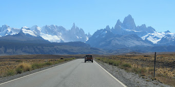
Patagonian Mountains Rise as Ice Caps Shrink


Mount Fitz Roy and surrounding peaks on the border between Argentina and Chile.
(Photo: Ben Tiger)


The icefields that stretch for hundreds of miles atop the Andes in Chile and Argentina are melting at some of the fastest rates on the planet. The ground that was beneath this ice is rising as these glaciers disappear.

Geologists have discovered a link between recent ice mass loss, rapid rock uplift and a gap between tectonic plates that underlie Patagonia.

Scientists at Washington University in St. Louis, led by seismologist Douglas Wiens, the Robert S. Brookings Distinguished Professor in Arts & Sciences, recently completed one of the first seismic studies of the Patagonian Andes. In a new publication in the journal Geophysical Research Letters, they describe and map out local subsurface dynamics.

Shrinking icefields have reduced weight that previously caused the continent to flex downward. The scientists found very low seismic velocity within and around the gap, as well as a thinning of the rigid lithosphere overlying the gap. The ongoing movement of land is known as glacial isostatic adjustment.

These particular mantle conditions are driving many of the recent changes that have been observed in Patagonia, including the rapid uplift in certain areas once covered by ice. 

Researcher Wiens reports, "Low viscosities mean that the mantle responds to deglaciation on the time scale of tens of years, rather than thousands of years, as we observe in Canada for example." Wiens explains, "This explains why GPS has measured large uplift due to the loss of ice mass.

"Another significant thing is that the viscosity is higher beneath the southern part of the Southern Patagonia Icefield compared to the Northern Patagonia Icefield, which helps to explain why uplift rates vary from north to south," Wiens said.

Wiens specializes in seismology and geophysics and has done extensive research on large deep earthquakes in the Pacific Ocean, the effect of ice melt, and the seismology of Antarctica. 

Read more herehere, and here.


Tuesday, June 15, 2021

A New Ocean Forming in the Afar Region


A 35-mile-long rift opened up in the Ethiopian desert in 2005, the result of tectonic plates slowly spreading the continent apart. (Photo credit: University of Rochester)

The Afar region of East Africa is experiencing dramatic changes due to rifting. Over time, these rifting events will reshape the African continent.

Each of the three plates in the Afar region is spreading at different speeds. The Arabian plate is moving away from Africa at a rate of about 1 inch per year, while the two African plates are separating between half an inch to 0.2 inches per year. The separation of these plates is creating a mid-ocean ridge system, where a new ocean will form.

Eventually, the Gulf of Aden and the Red Sea will flood in over the Afar region and into the East African Rift Valley and become a new ocean in a bout 5 million years. When that happens that part of East Africa will become a separate continent. 


Read more here: African Continent Slowly Peeling Apart 


Thursday, March 25, 2021

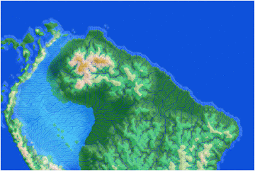
The Western Amazon Was a Sea?


Image credit: Tacio Cordeiro Bicudo (University of São Paulo, São Paulo, Brazil)


At intervals during the Miocene (23.03 to 5.333 million years ago) the Caribbean ocean surged into the western Amazon, creating a continuous inland sea. Saltwater currents mixed with fresh water from torrential rains. 

Researchers believe that the periods of flooding were relatively brief. For the majority of the epoch, the ocean receded, leaving a freshwater megawetland of interconnected lakes.

Scientists have found sediments as well as a fossilized shark tooth and a marine mantis shrimp, consistent with two separate Caribbean flooding periods in the last 20 million years. The geological and biological evidence suggests that during the Miocene the western Amazon region was a massive wetland, twice the size of Texas.

Read more here.


Thursday, December 17, 2020

The Crazy Colorado River


Recent geological research indicates that the Colorado river's route from the Colorado Plateau was influenced by tectonic deformation and vaciliating sea levels that caused a series of stops and starts between 6.3 and 4.8 million years ago. A team led by geologist Rebecca Dorsey of the University of Oregon has made a case for a complex history of the river, showing that, contrary to conventional thinking, a river's connection to the ocean is not a once-and-done deal.

"The birth of the Colorado River was more punctuated and filled with more uneven behavior than we expected," Dorsey said. "We've been trying to figure this out for years. This study is a major synthesis of regional stratigraphy, sedimentology and micropaleontology. By integrating these different datasets we are able to identify the different processes that controlled the birth and early evolution of this iconic river system."

Dorsey said that no single process controlled the Colorado River's initial route to the sea. "Different processes interacted in a surprisingly complicated sequence of events that led to the final integration of that river out to the ocean," she said.

The region covered in the research stretches from the southern Bouse Formation, near present-day Blythe, California, to the western Salton Trough north of where the river now trickles into the Gulf of California. The Bouse Formation and deposits in the Salton Trough have similar ages and span both sides of the San Andreas Fault, providing important clues to the river's origins.

The Colorado River starts in the peaks of the Rocky Mountain in the United States and flows into Mexico, where it empties into the Upper Sea of Cortez. Its natural course has varied over thousands of years, and the demand for water to serve an estimated 40 million people now exceeds the river’s supply, resulting in the desiccation of the Colorado’s last hundred miles.

The Colorado River's seven basin states are managing water under the Drought Contingency Plan, an agreement to safeguard water levels at the river's two main reservoirs, Lake Mead and Lake Powell. The two lakes are critical to providing water in times of drought. The Colorado River Basin states are Arizona, California, Colorado, Nevada, New Mexico, Utah, and Wyoming.


Friday, January 24, 2020

Trilobite Migration or Conga Line?


Ampyx priscus in linear formation (Moroccan Lower Ordovician Fezouata Shale). Credit: Jean Vannier, Laboratoire de Geologie de Lyon: Terre, Planètes, Environnement (CNRS / ENS de Lyon / Université Claude Bernard Lyon 1)


Arthropod fossils dating back 500 million years show the creatures died in an orderly line 'while migrating'

Fossils of ancient arthropods discovered in linear formation may indicate a collective behavior either in response to environmental cues or as part of seasonal reproductive migration. The findings, which are being published in Scientific Reports this week, suggest that group behaviors comparable to those of modern animals existed as early as 480 million years ago.

Read more here.


Thursday, December 12, 2019

Floating Stones


A large accumulation of pumice has been drifting in the Southwest Pacific towards Australia. The point of origin of this pumice raft is a submarine volcano in Tongan waters. The highly porous pumice is of such low density that it floats.

Since August, this raft of pumice has been moving closer to Australia. Researchers were eager to identify the source and an image of the ESA satellite Copernicus Sentinel-2 taken on 6 August 2019, showed clear traces of an active underwater eruption. The volcano has been named Volcano F.

The debris from the eruption is expected to reach the Great Barrier Reef in late January and early February.

Read more here and here.


Tuesday, September 10, 2019

Geologists Solving the Greater Adria Puzzle


About 140 million years ago, Greater Adria was a Greenland-size landmass (submerged portions in gray-green). VAN HINSBERGEN ET AL., GONDWANA RESEARCH (2019)


About 100 million years ago, a Greenland-size landmass called Greater Adria collided with southern Europe and shattered into pieces as it was shoved beneath that continent. Only a fraction of Greater Adria’s rocks, scraped off in the collision, remained on Earth’s surface for geologists to discover.

In the new study, van Hinsbergen and his colleagues spent more than 10 years collecting information about the ages of rock samples thought to be from Greater Adria, as well as the direction of any magnetic fields trapped in them. That let the researchers identify not just when, but where, the rocks were formed.

Rather than simply moving north with no change in its orientation, Greater Adria spun counterclockwise as it jostled and scraped past other tectonic plates, Although the tectonic collision happened at speeds of no more than 3 to 4 centimeters per year, the inexorable smash-up shattered the 100-kilometer-thick bit of crust and sent most of it deep within Earth’s mantle.

Read the full report here.


Friday, October 20, 2017

Geologic Studies Confirm Biblical Data


Mysterious keyhole structures at Al Wadi, in the Saudi Arabian desert, observed by archaeologist David Kennedy from a helicopter.


Three regions are named in the Bible as being rich in minerals like copper and gold: Havilah at the source of the Nile in Kush (Genesis 2:11); Dedan in southwestern Arabia, and Ophir, south of Dedan.

The region of Dedan and Ophir is riddled with lava caves dating to many thousands of years ago. The archaic populations of Dedan and Ophir lived in these caves and collected epithermal gold. This is gold that is mined close to the surface because it has been brought up by volcanism.

Scientists have been studying this area. They are especially interested in the lava caves of Harrat Khaybar. Here researchers have found hundreds of stone walls surrounding large basaltic lava fields. The largest of the walls reaches almost 1,700 feet long. The stone walls were built during active volcanism. The structures at Harrat Khaybar are regarded as “works of the old men” by the Bedouin. The Bible calls them the "mighty men of old."


The lava caves and walls of Harrat Khaybar (Arabic for "White Mountain") are in the news today. Scientists have known about this region for 30 years. This is the region of biblical Dedan and Ophir, described as rich in precious metals. This is probably the oldest known site of recovery of copper and gold, and the miners lived in the caves, many of which collapsed long ago. Ophir was one the sons of Joktan (Gen. 10:26-28). The Joktanite clans still live in this region of Arabia.

This area of Saudi Arabia and Yemen is a site for porphyry copper and epithermal gold deposits captured by people living in the caves.


In 1946 an inscribed pottery shard was found at Tell Qasile (Tel Aviv) dating to the eight century BC. The Paleo-Hebrew inscription says, "gold of Ophir for Beth-Horon [...] 30 shekels." This, and other such finds, confirm that gold was exported from Ophir. 

Every three years Solomon received tribute of gold, silver, sandalwood, precious stones, ivory, apes and peacocks from Ophir. Solomon's navy traveled to Ophir, taking "four hundred and twenty talents of gold from there" (1 Kin. 9:26-28; 22:48; 2 Chr. 8:17-18; 9:10).